Posted by Admin on 19-07-2023 in Shiksha hub
Land Survey Assistant Admission, Registration, Eligibility, Duration, Fees, Syllabus 2024
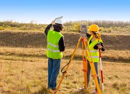
Introduction about Land Survey Assistant
A Land Survey Assistant is a crucial member of a land surveying team, contributing to the accurate measurement, mapping, and analysis of geographic features and boundaries. This role involves a combination of fieldwork and office tasks, requiring both practical skills and a solid understanding of surveying principles.
In the field, a Land Survey Assistant works alongside licensed surveyors, utilizing specialized equipment such as total stations, GPS receivers, and laser levels to measure distances, angles, and elevations. They may also assist in setting up survey control points and markers, ensuring precision in data collection. Physical fitness and an ability to work in various environmental conditions are often essential for this aspect of the role.
In the office, the Land Survey Assistant plays a vital role in data processing, employing computer-aided design (CAD) software and geographic information systems (GIS) to organize and analyze survey data. They may be responsible for creating detailed maps, reports, and other documentation that provide valuable information for land development, construction projects, and property boundary determination.
Strong communication skills are essential for a Land Survey Assistant, as they often collaborate with other team members, clients, and stakeholders. Attention to detail and a commitment to accuracy are paramount, as survey data is critical for legal, engineering, and construction purposes. Additionally, an understanding of relevant laws and regulations pertaining to land surveying is important to ensure compliance with local requirements.
Overall, the role of a Land Survey Assistant is integral to the success of surveying projects, contributing to the creation of reliable and precise maps and data that serve as the foundation for informed decision-making in various industries.
How can I apply for admission to Land Survey Assistant program
To apply for admission to a Land Survey Assistant program, you typically need to follow a set of steps outlined by the educational institution offering the program. Here is a general guide on how you can apply:
Research Programs:
Look for educational institutions that offer Land Survey Assistant programs. This could include community colleges, technical schools, or vocational training centers.
Check Admission Requirements:
Review the admission requirements for the specific program you are interested in. These may include educational prerequisites, such as a high school diploma or equivalent, and any specific coursework or skills.
Prepare Necessary Documents:
Gather the required documents for your application. This may include transcripts, letters of recommendation, a resume, and a personal statement. Make sure to check the specific requirements of the program.
Application Form:
Fill out the application form provided by the institution. This is often available online on the institution's official website. Follow the instructions carefully and provide accurate information.
Application Fee:
Pay any application fees that may be required. Some institutions charge a fee to process your application. Check the institution's website or contact the admissions office for details.
Submit Application:
Submit your completed application form and all required documents by the specified deadline. Many institutions allow online submission, but some may still require physical copies.
Interview (if required):
Some programs may require an interview as part of the admission process. If so, be prepared to discuss your interest in the field and your motivation for pursuing a career as a Land Survey Assistant.
Wait for Admission Decision:
After submitting your application, you will need to wait for the admission decision. This may take a few weeks, so be patient. Some institutions will notify you by mail or email.
Financial Aid (if needed):
If you require financial aid, explore scholarship and grant opportunities. Fill out the Free Application for Federal Student Aid (FAFSA) if you are in the United States.
Enrollment:
If accepted, follow the instructions provided by the institution to complete the enrollment process. This may include paying tuition and attending orientation sessions.
What is the eligibility for Land Survey Assistant
The eligibility criteria for a Land Survey Assistant program may vary depending on the educational institution offering the program. However, here are some common eligibility requirements that you might encounter:
Educational Background:
Typically, a high school diploma or equivalent (such as a GED) is required for admission to a Land Survey Assistant program. Some programs may also have specific coursework prerequisites, so it's essential to check for any academic requirements.
Math and Science Proficiency:
Given the technical nature of land surveying, proficiency in mathematics and science is often required. Programs may specify certain math and science courses that applicants should have completed in high school.
Age Requirements:
Some programs may have age requirements, often related to legal regulations for working in the field or for the use of specific surveying equipment. Check with the specific program to see if there are any age restrictions.
Physical Fitness:
Land surveying often involves fieldwork that can be physically demanding. As a result, some programs may assess applicants for their physical fitness and ability to work outdoors in various conditions.
Computer Skills:
With the increasing use of technology in surveying, basic computer skills are often beneficial. Some programs may require or prefer applicants to have a certain level of proficiency in using computer software, including computer-aided design (CAD) and geographic information systems (GIS).
Interview or Assessment:
In some cases, applicants may be required to undergo an interview or assessment process. This could be to gauge their interest in the field, assess their communication skills, or evaluate their aptitude for surveying-related tasks.
Legal Requirements:
Depending on the region or country, there may be legal requirements for individuals entering the field of land surveying. This could include obtaining certain licenses or certifications. While these are typically associated with more advanced roles, it's essential to be aware of any industry-specific regulations.
It's crucial to check the specific eligibility requirements of the Land Survey Assistant program you are interested in. This information is usually available on the program's official website or can be obtained by contacting the admissions office of the educational institution offering the program. If you have any questions or if there are specific circumstances you're uncertain about, reaching out to the admissions staff for clarification is always a good practice.
How long does it take to complete a Land Survey Assistant program
The duration of a Land Survey Assistant program can vary depending on the type of educational institution offering the program, the specific curriculum, and the format of the program (e.g., full-time or part-time). Generally, Land Survey Assistant programs are designed to provide a relatively short and focused education to prepare individuals for entry-level positions in the field. Here are some common scenarios:
Certificate Programs:
Many Land Survey Assistant programs are offered as certificate programs, which can typically be completed in less than a year. These programs focus on providing the fundamental skills and knowledge needed for a career as a Land Survey Assistant.
Associate Degree Programs:
Some institutions may offer an Associate of Applied Science (AAS) degree in Land Surveying Technology or a related field. These programs often take about two years to complete if pursued on a full-time basis.
Part-Time or Online Programs:
If you choose to attend a program on a part-time basis or through online courses, the duration may vary. Part-time programs might take longer to complete, and online programs often offer flexibility, allowing students to progress at their own pace within certain time constraints.
Internship or Work Experience:
Some programs may include a mandatory internship or work experience component, which could extend the overall duration of the program. This practical experience is valuable for gaining hands-on skills in real-world surveying scenarios.
What are potential career opportunities after Land Survey Assistant
Completing a Land Survey Assistant program can open up various career opportunities in the field of land surveying and related industries. While a Land Survey Assistant typically performs support tasks under the supervision of licensed surveyors, gaining experience and additional qualifications can lead to advancement in the profession. Here are some potential career opportunities:
Land Survey Technician:
With experience, Land Survey Assistants can advance to become Land Survey Technicians. In this role, individuals may take on more responsibilities in data collection, analysis, and map preparation. Technicians often work closely with licensed surveyors to ensure the accuracy of surveying projects.
GIS Technician:
Some Land Survey Assistants may choose to specialize in Geographic Information Systems (GIS). GIS Technicians use spatial data to create maps and visualizations for various purposes, including land use planning, environmental analysis, and infrastructure development.
CAD Technician:
A background in computer-aided design (CAD) gained during a Land Survey Assistant program can lead to a career as a CAD Technician. These professionals work on drafting and designing technical drawings, including those used in land surveying.
Survey Crew Chief:
With additional experience and possibly further education, individuals can progress to become Survey Crew Chiefs. In this role, they may lead survey crews in the field, overseeing data collection and ensuring that survey projects meet quality standards.
Survey Party Chief:
Similar to a Survey Crew Chief, a Survey Party Chief is responsible for managing surveying activities in the field. This role often involves supervising a team of surveyors, ensuring accurate data collection, and coordinating surveying projects.
Land Surveyor (with licensure):
After gaining enough work experience and meeting the educational requirements, individuals may pursue licensure as a Professional Land Surveyor (PLS). Licensed Land Surveyors have the authority to oversee and certify survey projects independently, opening up opportunities for entrepreneurship and leadership roles.
Construction Surveyor:
Some Land Survey Assistants may choose to specialize in construction surveying. Construction Surveyors work on projects such as building construction, road development, and infrastructure projects, ensuring that structures are built according to design specifications.
Land Development Coordinator:
In the realm of land development, individuals with a background in land surveying may take on roles coordinating various aspects of development projects. This could involve liaising with engineers, planners, and other professionals to ensure compliance with regulations.
Syllabus for Land Survey Assistant
The specific syllabus for a Land Survey Assistant program can vary depending on the educational institution offering the program. However, here is a general outline that covers key topics commonly included in Land Survey Assistant programs:
Introduction to Surveying:
Overview of the surveying profession
Historical development of surveying
Basic surveying terminology and concepts
Mathematics for Surveying:
Fundamental mathematical concepts used in land surveying
Trigonometry and its applications in surveying
Geometry and algebra relevant to survey calculations
Field Surveying Techniques:
Use of surveying instruments such as total stations, levels, and GPS devices
Measurement of distances, angles, and elevations in the field
Setting up survey control points
Land Measurement and Legal Descriptions:
Principles of land measurement
Legal descriptions of land parcels
Boundary laws and regulations
Computer-Aided Design (CAD) for Surveying:
Introduction to CAD software used in surveying
Drawing and drafting techniques for creating survey maps
Digital data manipulation and representation
Geographic Information Systems (GIS) Basics:
Introduction to GIS concepts
Spatial data analysis and mapping
Integration of GIS with surveying data
Data Collection and Processing:
Techniques for collecting field data
Processing and managing survey data
Quality control and error detection in survey data
Construction Surveying:
Surveying applications in construction projects
Layout and staking for construction sites
Monitoring and verifying construction activities
Professional Communication and Ethics:
Effective communication within surveying teams
Ethical considerations in land surveying
Client and stakeholder interactions
Safety in Surveying:
Occupational health and safety practices in surveying
Use of personal protective equipment
Emergency procedures in the field
Internship or Practical Experience:
Hands-on experience in the field or through simulated exercises
Application of classroom learning to real-world surveying scenarios
Integration of theoretical knowledge with practical skills
How long does it take to complete a Land Survey Assistant program
The duration of a Land Survey Assistant program can vary depending on several factors, including the type of program, the educational institution, and whether you are enrolled on a full-time or part-time basis. Here are some general timelines for different types of programs:
Certificate Programs:
Land Survey Assistant certificate programs are often designed to be completed in a relatively short period, typically ranging from a few months to a year. These programs focus on providing the essential skills and knowledge needed for entry-level positions in land surveying.
Associate Degree Programs:
If you choose to pursue an Associate of Applied Science (AAS) degree in Land Surveying Technology or a related field, the program is generally designed to be completed in about two years of full-time study. Part-time students may take longer to finish.
Part-Time or Online Programs:
The duration of the program can be extended for part-time students, allowing flexibility for individuals who are working or have other commitments. Online programs may also offer a flexible schedule, and the duration can vary based on the student's pace.
Internship or Work Experience:
Some programs may include mandatory internships or work experience components, which could extend the overall duration of the program. These practical experiences are valuable for applying classroom learning to real-world situations.
Scholarship and Grants for Land Survey Assistant
Scholarships and grants for Land Survey Assistant programs may be available from various sources, including educational institutions, professional organizations, and industry associations. Here are some potential avenues to explore when seeking financial assistance for your education:
Educational Institutions:
Many colleges and universities offer scholarships or grants to students enrolled in specific programs, including those related to land surveying. Check with the financial aid office or the department offering the Land Survey Assistant program to inquire about available opportunities.
Professional Organizations:
Explore scholarships provided by professional organizations related to surveying and geomatics. For example, organizations like the National Society of Professional Surveyors (NSPS) or state-level surveying associations may offer financial assistance to students pursuing careers in surveying.
Industry Associations:
Look for scholarships or grants offered by industry associations associated with land surveying, geospatial sciences, or construction. These organizations may have funding opportunities to support students in related fields.
Government Programs:
Check if there are government-sponsored scholarships or grants available for students pursuing careers in fields like surveying. These may be offered at the federal, state, or local levels.
Private Foundations:
Some private foundations and philanthropic organizations provide scholarships for students pursuing careers in technical fields. Research foundations that have an interest in education and technology.
Employer Assistance:
If you are currently employed or plan to work in the field while studying, inquire about employer-sponsored education assistance programs. Some employers offer financial support for employees seeking to enhance their skills through education.
Online Scholarship Search Platforms:
Utilize online scholarship search platforms to discover a wide range of scholarships available for students in technical and vocational fields. Websites like Fastweb, Chegg, and College Board's Scholarship Search can be helpful in identifying relevant opportunities.
Community and Civic Organizations:
Local community groups, civic organizations, or foundations may offer scholarships to support individuals pursuing technical education. Check with local entities to explore potential sources of financial aid.
Conclusion
In conclusion, the role of a Land Survey Assistant is a pivotal one within the field of surveying, bridging the gap between foundational knowledge and practical application. These professionals contribute significantly to the accurate measurement, mapping, and analysis of geographic features, playing a crucial role in various industries such as construction, land development, and environmental planning.
FAQ’s
What is a Land Survey Assistant?
A Land Survey Assistant is a professional who supports licensed surveyors in measuring and mapping the Earth's surface. They assist in collecting data, using surveying instruments, and processing information for various projects.
What does a Land Survey Assistant do?
Land Survey Assistants perform a range of tasks, including fieldwork to measure distances and elevations, setting up surveying equipment, collecting data, and assisting in the creation of maps and survey reports.
What qualifications are required to become a Land Survey Assistant?
Typically, a high school diploma or equivalent is required. Some programs may have specific math and science prerequisites. Strong mathematical skills, attention to detail, and physical fitness are often essential.
How long does it take to become a Land Survey Assistant?
The duration varies depending on the type of program. Certificate programs may take a few months to a year, while an Associate Degree program may take about two years if pursued on a full-time basis.
What skills are important for a Land Survey Assistant?
Important skills include proficiency in mathematics, attention to detail, physical fitness for fieldwork, knowledge of surveying instruments, computer skills for data processing, and effective communication.
Can I work while pursuing a Land Survey Assistant program?
Depending on the program structure, some students may choose to work part-time while attending classes. Online or evening programs might offer more flexibility for those with work commitments.
Are there internship opportunities during the program?
Many Land Survey Assistant programs include internships or practical experiences, providing students with hands-on training in real-world surveying situations.
What career opportunities are available after completing a Land Survey Assistant program?
Graduates can pursue roles such as Land Survey Technician, GIS Technician, CAD Technician, or advance to become licensed Land Surveyors with additional education and experience.
Are there scholarships or financial aid options for Land Survey Assistant programs?
Yes, scholarships and grants may be available from educational institutions, professional organizations, and government programs. It's advisable to explore various sources for financial assistance.
How can I become a licensed Land Surveyor?
To become a licensed Land Surveyor, individuals typically need to meet specific education and experience requirements, pass a licensing exam, and adhere to the licensing regulations of the relevant jurisdiction.
How Shiksha Hub helps you in
-
 Student Counsellors
 -
 Career Counseling
 -
 Research
 -
 24/7 Support
 -
 Scholarships
 -
 Community